New Sawyer Project

New Sawyer Gold Project

New Sawyer Project

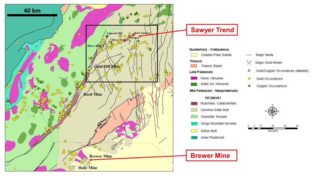
The New Sawyer Project’s land package is 246.6 hectares and contains the historic New Sawyer Gold Mine which includes 12 identified vertical  shafts.  The property lies within the Sawyer-Keystone Gold Trend (“Sawyer Trend”), a >20 km long structurally-controlled alignment of volcanic-hosted, Haile-type alteration and historic gold mines (Moye, 2018).   The New Sawyer mine and the Sawyer Trend are located in Randolph County, North Carolina.


The mine was in operation before the turn of the century, but no production figures are available. It is hosted in Haile-type sericitically altered volcanic rocks and lie along an extensive zone of mineralization going several miles to the southwest.


Some sampling was carried out in the 1930s (Carpenter, 1976). Several shafts, some of up to 100 feet in depth, were sunk on the property in the late 1800s, probably by the same people that worked the Sawyer Mine, three miles to the southwest.


Numerous old trenches and workings are scattered along a ridge of intensely altered volcanic rocks for over 1000 feet. One old report quotes assays from .057 to .24 ounces per ton in the old workings, with one 87 feet width averaging 0046 ounces per ton (Pardee and Park, 1948).


The New Sawyer Mine, like the Sawyer to the southwest, has been labeled by some as being hosted in a hot springs, exhaustive gold system, at or near the top of the Umwharrie Formation (Worthington, et al, 1980). This is the same stratigraphic vicinity in which is found the Haile, Brewer, and possibly Ridgeway discoveries, and this volcanic-sediment contact has repeatedly proven itself a worthy setting to explore. (Worthington and Kiff, 1970).


In the late 1980s, it was trenched and a small amount of drilling was performed in the property. Extensive ore-grade gold bearing rock can be found in trenches across a thousand feet of strike length and in places up to 100 feet in width. Subsequent limited RC drilling has shown ore grades to 60 feet in depth above low-grade mineralization. The property has potential for hosting a large tonnage, low-grade disseminated gold deposit of Haile type, but additional trenching and drilling is warranted. The anomalies that have been located are for the most part open ended to the northeast and southwest. Old prospect pits can be found on the property for a strike distance of 3000 feet.

History

The New Sawyer Mine was briefly described by the U.S.G.S. in Professional Paper 213 (Pardee & Park, 1948) where they reported prior surface sampling and noted multiple shafts ranging from 10 – 20 meters in depth.  Records indicated the mine was in production in 1902, however nearby properties were operating much earlier in 1856.  Gold was produced from multiple zones hosted in a large zone of Haile-type sericite-pyrite-clay alteration.  No production records are available.  The property has since been explored by three companies to varying degrees, starting in the 1980s:


1986-88:  Battle Mountain Gold completed systematic soil sampling (357 samples), trenching (13 trenches/1157 m), 6 reverse circulation drill holes and 3 core holes.  Soil sampling identified two continuous soil anomalies, the main anomaly extending 650 meters northeast and approximately 200 meters wide, with a second anomaly along trend extending 150 meters northeast and about 80 meters wide.  Trenches constructed within this anomaly  identified significant gold values in 6 of 8 trenches.   


2012: Romarco drilled six  holes, no data available.


2019 – 20: Carolina Mining Company (“CMC”) compiled historic data and re-excavated portions of two historic trenches within the historic soil gold anomaly to verify the historic results reported by Battle Mountain Gold.  Two 30-meter long mechanical trenches were oriented northwest-southeast across the fabric of the geology, located about 100 meters apart.  The trenches were excavated with a track hoe to the point of refusal.  Continuous chip channel samples of oxidized bedrock were collected and analysed using CIMM Best Practices and  QA/QC procedures according to NI 43-101 recommendations. Trench results confirmed the historic results and included:

  • Trench NS-1: 0 meters @ 1.6 g/t Au  from 0 – 30m    (open in both directions), including 16.0 meters @ 2.2 g/t Au, from 12-28 m
  • Trench NS-2: 0 meters @ 1.0 g/t Au from 0 – 30 (open in both directions), including 10.0 meters @ 2.1 g/t Au, from 20 – 30 m (see figures below)


CMC also completed a helicopter-supported VTEM and Magnetics survey covering the property.


The New Sawyer property contains significant historic results that will be incorporated in a systematic evaluation of gold distribution on the property and within the Sawyer Trend, incorporating new ideas and concepts established recently by the successful developments at the Haile Gold Mine.  The New Sawyer property has potential for near surface, oxide, bulk-mineable gold-mineralization within a large, structurally controlled alteration zone that has not been explored.

Photo Gallery

Location Map

New Sawyer Trench NS-1

New Sawyer Trench NS-2